


A new engineering assessment has found that landslide risk has dropped at most properties along the District of North Vancouver’s escarpment slopes, but it has flagged two homes on Rivergrove Place where risk now exceeds the District’s safety threshold. That is largely due to a deteriorating retaining wall on a neighbouring property.
The findings come from an updated quantitative risk assessment by BGC Engineering Inc., commissioned by the District of North Vancouver (DNV), and are based on more than 15 years of slope monitoring that began after the January 19, 2005 landslide on the Berkley Escarpment.
That slide prompted the District’s risk management program for escarpment and debris-flow hazards, which BGC has now revisited using updated topography, newer methodology and over a decade of additional data.
Sign up for news alerts from the North Shore Daily Post
What the study covered
BGC’s update focused on seven escarpments most prone to rapid earth flows, debris flows and rockfall, the landslide types most likely to threaten life: Berkley, Pemberton Heights, Westlynn, Riverside West, Mosquito Creek, West Hastings and Capilano River East. The District has recorded seven known flow slides from its escarpments since 1972, two of which, in 1979 and 2005, caused structural damage to homes below.
BGC compared lidar elevation data from 2013 and 2022 to assess slope movement or other changes that could affect stability. The comparison mostly revealed routine changes such as building modifications, road work, the aftermath of the Seymour River rock slide, and new steep-creek mitigation work, with limited evidence of new movement on the escarpments themselves. That’s consistent with a historical record showing only three landslides District-wide between 2005 and 2024, which BGC says points to the effectiveness of mitigation work done since 2005.

Two properties exceed the safety threshold
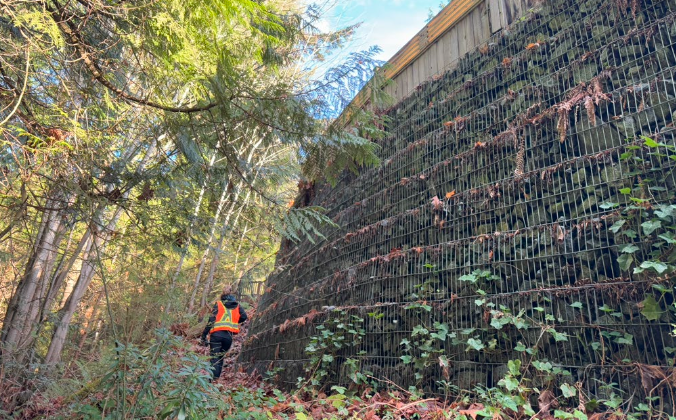
Despite the reassuring trend, BGC found that two properties on Rivergrove Place now exceed the District’s risk tolerance threshold of 1-in-10,000 annual probability of death. The elevated risk stems from the properties’ proximity to the slope, its height and angle, and a deteriorating retaining wall on an upslope property.
A staff report to council confirms that the District has notified the wall’s owners and that work is already underway to remove the wall, its retained fill, and reshape the slope. Staff say this work, combined with the report’s findings, resolves the unacceptable risk identified.
BGC also flagged two properties on Riverside Drive as sitting near, though not over the threshold, within the analysis’s margin of uncertainty. The District has been advised to discuss risk levels and mitigation options with those owners.

The bigger picture: risk is trending down
Outside those specific locations, the report describes broad improvement. Of 149 properties assessed at the base of escarpment slopes, 127 — about 85 percent — carry lower risk than in previous assessments, with 41 dropping from “tolerable” to “broadly acceptable.” All 124 properties assessed at the crest were rated “broadly acceptable.” Where risk rose slightly at a handful of properties, it stayed within the same risk category.
BGC credits the improvement to mitigation work completed since 2005, an extended historical record supporting a lower estimate of landslide frequency, and a refined method that accounts for decreasing impact pressure with distance and the protective effect of upslope buildings.
BGC also screened 183 base-of-slope and 355 crest-of-slope properties within the District’s Slope Hazard Development Permit Area but outside the seven escarpments studied in detail. None exceeded risk tolerance criteria, though the screening is a preliminary tool rather than a site-specific assessment.
Recommendations going forward
Property owners at the crest of slopes are advised to direct stormwater away from slope edges, avoid dumping yard waste over the escarpment, and have a professional assess any changes to retaining walls, pools, structures or trees nearby. BGC’s field work found lawn clippings, garden debris and saturated fill dumped at escarpment crests, material that can destabilize slopes.
The District is advised to continue enforcing its Slope Hazard Development Permit Area, consider a modest expansion based on updated runout modelling, repeat the district-wide assessment roughly every decade, and consider a formal inspection program for retaining walls, particularly aging timber and log-crib structures. BGC also prepared a separate technical guidance memo for developers and property owners, which the District has been encouraged to publish.
Staff says that releasing the assessment publicly will not expose the District to additional liability and will require no new funding, though the council will be updated on costs for any expanded monitoring, including regular lidar collection. Staff also pointed to climate change and increasingly frequent, intense rainfall as a reason for continued investment in proactive risk assessment and public education.


